![Director of National Parks [logo]](/images/dnp_90px.gif)

|
|
 Research Archive Document, 1991
This article was originally published in 'Australian Horticulture' 89(8): 37–39 (1991), when the author was employed by CSIRO Plant Industry.
by Iain Dawson (Horticultural Research
Unit, ANBG) 1991
(Iain has since retired from the Australian National Botanic
Gardens)
Plant hardiness maps allow producers to label their plants as being suitable for particular areas, and, in theory at least, this results in happy customers who can confidently buy plants that will survive in their locality.
Early last year [i.e. 1990] the United States Department of Agriculture (USDA) published an updated version of their map of plant hardiness zones. This divides the United States into 11 zones (1-11), characterised by their average minimum temperature. Zones 2 to 10 are also subdivided into 'A' or 'B', giving a total of 20 zones or sub-zones. These zones of course only apply to plants growing out of doors with no protection, but which are provided with adequate water.
It has been suggested that such a map would be useful for Australia (Australian Horticulture, May 1990).
This would be an aid to the plant buyers in Australia, as well as helping exporters to the USA describe the hardiness of their plants in a common language. Similar maps have been drawn before, such as those on the back of many seed packets, but as far as I know none has ever been comparable with the American system.
The statistic used by the USDA is the average annual minimum temperature. This causes immediate confusion. In Australia we use this term to mean the average minimum temperature over the whole year, whereas the USDA means the average, over ten or more years, of the very lowest temperature observed for each year for each meteorological station.
I prefer to call the USDA term the average annual lowest temperature. This figure tends to make places look very cold! For example, Florida, which we think of as a warm place, is in the US Zone 10 which has minimum temperatures from 30°F to 40°F (-1°C to +4°C). Zone 1 (e.g.central Alaska) is below -50°F (-45°C) which is very cold!
I have used the same statistic for Australia, but rather than use US zones directly I have modified the limits for each zone. This is because Australia, in winter, is much warmer than most of North America in winter, so the lowest US zones aren't relevant. All of Australia (excluding Macquarie Island) is covered by just over four US zones (7b–11). To make the map more useful to Australians I have created 7 zones to fit our climatic range, and used metric units.
The limits to each zone, and a comparison of US and Australian zones, are shown alongside the map.
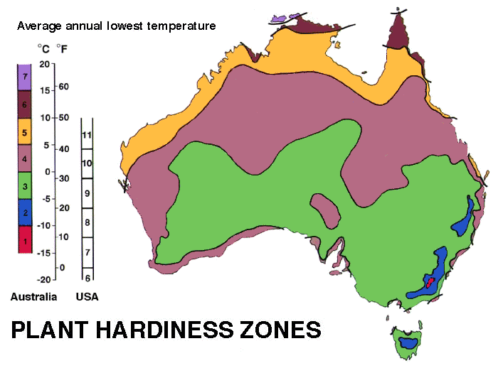
The main factors determining average minimum temperature are altitude, latitude and proximity to the coast.
Zone 1 covers the alpine areas of south eastern Australia.
Zone 2 the tablelands of south east Queensland, New South Wales and Victoria, and the uplands of central Tasmania.
Much of the southern half of the continent is in Zone 3, except for localities on or near the coast.
Many of our weather stations are on the coast or on off-shore islands (some of them are lighthouses) and these are often a zone or two higher than adjacent mainland stations because of the warming effects of the ocean in winter.
As a result of this warming effect Zone 4, which covers a broad area from coastal Queensland across the continent to Shark Bay and Geraldton in the west, also includes Sydney and the north coast of NSW, the Mornington Peninsula, areas adjacent to Spencer Gulf and Adelaide, the south western coastal zone, along with a number of localities dotted all around the southern coast of the continent.
Zone 5 covers, some of the Queensland coast, Western Australia north of Shark Bay and across the Top End. Zone 6 includes the Queensland coast north of Cairns, Cape York Peninsula and the coast of the Northern Territory. Zone 7 is mainly restricted to islands off the north coast.
There are many problems with maps of this type. For example, the spread of weather stations is insufficient to give good resolution of the zones and too many places with different climates are lumped together. In Australia we have only 738 stations with a record of more than ten years. This is one station per 98,491 ha.
Admittedly, the more populated areas have relatively fewer hectares per station but the basic difficulty remains. Even worse are the problem of local factors such as aspect, altitude, proximity to the sea and so forth. For example, Mt Isa has three climatic stations with more than a ten year record.
One is in Zone 4a, one in Zone 4b and the other is in Zone 5a.
Sydney residents can choose between Zones 3a to 4b depending which station is used. Most other cities have similar problems. Everyone is aware that different locations in the same city or suburb are suitable for different plants but it is hard to quantify these differences and even harder to draw a meaningful map.
There may even be a case for publishing a list of weather stations and their zone Classification so that people can decide for themselves which is the most appropriate location to use for their local conditions.
Plant hardiness refers to their ability to survive the conditions of a particular location, including tolerance of heat, soil moisture, humidity and so on. This map is based only on how well they survive low temperatures in winter.
Even that is a gross oversimplification. For example, are plants affected more by a single extremely low temperature night, or is the number of days of frost (the duration of winter) more important? In fact both are important, but the statistic for the map only relates directly to the former.
Another limitation is that often plants will survive in an area for some time, but every now and then there will be a catastrophic cold snap that will kill them.
Some risk evaluation — the probability of getting a particularly severe low temperature — often would be more useful for each locality rather than the average conditions. Also, many plants will survive in a locality but won't flower if the day length is inappropriate or if they require vernalisation (a particular duration of low temperature).
The low temperature statistic is only appropriate for woody perennial species, and even then its use is limited. With annuals the time of planting can often be adjusted to allow growth beyond their normal geographical range.
The map is only useful as a very broad guide. It needs interpretation that takes into account factors other than low temperature that limit plant growth as well as local knowledge.
An alternative system for describing plant hardiness is to use indicator plants (the USDA also publishes a list of these to go with their map). Common plants with known limits to their range are generally used for this purpose. For example, many people will know whether lemons will grow in their locality. If you then say Geraldton wax will grow more or less where lemons will grow you have defined the range of Geraldton wax with some accuracy . Unfortunately no two plant species seem to have exactly the same requirements and even within a species there are differences.
At some time in the future I think we will probably get around the problems associated with plant/climate maps with much more sophisticated data base systems that combine complex climate statistics and advanced plant growth models.
There are already software packages available to help you select landscaping plants. Two that I have seen are the 'Grow What Where' computer version, published by The Australian Plant Study Group, and 'Plantguide' from Arbordata.
However, these have limited climatic inputs. You are asked, for example, to select between fairly vague zones such as 'warm temperate' or 'eastern tablelands'.
Climatic data bases that allow you to assess the chances of particular climatic events taking into account some local factors (eg what are the chances of getting more than five consecutive nights with temperatures lower than -10°C on a south facing slope in Canberra?) combined with data bases containing detailed knowledge of plant responses to their environment (eg how many nights of frost can Pandorea jasminoides survive?) will go a long way towards answering the question of what grows where.
In the near future, when the customer asks if a particular plant will grow in their garden, the retailer will probably turn to a computer, not a map, to find the answer.